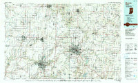
1986 Map of Muncie
USGS Topo · Published 1990About this map
The Mississinewa River and White River define the agricultural and industrial drainage of East Central Indiana in this mid-1980s landscape. Central to the map is the expansion of Muncie, anchored by the campus of Ball State University and its proximity to the Prairie Creek Reservoir to the southeast. The regional economy is traced through a dense network of smaller industrial and railway-linked towns such as Gas City, Hartford City, and Dunkirk.
Find a feature on this map
189 named features on this map. Tap any name to fly to it.
Don’t see what you’re looking for? This feature index may not catch every label — zoom into the map to look around manually.
Map Details
Editions of this 1986 Muncie Map
3 editions found
Other maps of this area

1911 · Berne
USGS Topo · 1:48,000

1915 · Fort Recovery
USGS Topo · 1:48,000

1915 · New Paris
USGS Topo · 1:48,000

1916 · Winchester
USGS Topo · 1:48,000

1918 · Winchester
USGS Topo · 1:62,500

1918 · Fort Recovery
USGS Topo · 1:62,500

1918 · New Paris
USGS Topo · 1:62,500

1943 · Winchester
USGS Topo · 1:62,500

1949 · New Castle West
USGS Topo · 1:24,000

1950 · New Castle East
USGS Topo · 1:24,000