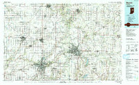
1986 Map of Muncie
USGS Topo · Published 1993About this map
Industrial hubs and university towns anchor this mid-1980s portrait of East Central Indiana. The urban corridors of Muncie and Anderson dominate the landscape, connected by a network of state routes and the Norfolk and Western RR. The map captures a region defined by its water systems, from the winding White River and Mississinewa River to the significant recreational expanse of the Prairie Creek Reservoir southeast of the Muncie city center. Small agricultural and manufacturing centers like Gas City, Elwood, and Hartford City are shown at a time of transition, surrounded by a grid of rural roads and numerous gravel pits and quarries that reflect the local geology. Significant regional transport infrastructure is evident, including the Anderson Municipal Airport and the path of I-69, which facilitated the movement of goods and people between these manufacturing cities and the state capital to the southwest.
Find a feature on this map
92 named features on this map. Tap any name to fly to it.
Don’t see what you’re looking for? This feature index may not catch every label — zoom into the map to look around manually.
Map Details
Editions of this 1986 Muncie Map
3 editions found
Other maps of this area

1911 · Berne
USGS Topo · 1:48,000

1915 · Fort Recovery
USGS Topo · 1:48,000

1915 · New Paris
USGS Topo · 1:48,000

1916 · Winchester
USGS Topo · 1:48,000

1918 · Winchester
USGS Topo · 1:62,500

1918 · Fort Recovery
USGS Topo · 1:62,500

1918 · New Paris
USGS Topo · 1:62,500

1943 · Winchester
USGS Topo · 1:62,500

1949 · New Castle West
USGS Topo · 1:24,000

1950 · New Castle East
USGS Topo · 1:24,000