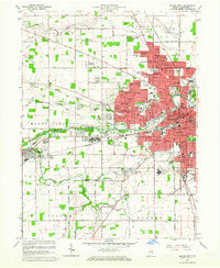
1962 Map of Muncie West
USGS Topo · Published 1964About this map
Ball State Teachers College serves as a central anchor for the urban expansion of Muncie during the early 1960s. This survey illustrates the post-war suburban shift through a dense collection of housing developments such as Halteman Village, Devon Park, and Western Ridge. The landscape is bisected by the White River and the New York Chicago and St Louis RR, which helped shape the industrial and residential corridors of Yorktown and the surrounding townships. Local genealogy is well-supported by the presence of numerous family-named landmarks and burial grounds, including the Nottingham Cem and McKinley Cem. The map also captures the city's civic infrastructure, from the Courthouse and City Hall to a variety of neighborhood schools like Storer High Sch and Riley Sch.
Find a feature on this map
94 named features on this map. Tap any name to fly to it.
Don’t see what you’re looking for? This feature index may not catch every label — zoom into the map to look around manually.
Map Details
Editions of this 1962 Muncie West Map
This is the sole edition of this map. No revisions or reprints were ever made.
Other maps of this area

1952 · Muncie East
USGS Topo · 1:24,000

1952 · Muncie West
USGS Topo · 1:24,000

1953 · Muncie
USGS Topo · 1:250,000

1956 · Muncie
USGS Topo · 1:250,000

1960 · Gilman
USGS Topo · 1:24,000

1960 · Middletown
USGS Topo · 1:24,000

1960 · Eaton
USGS Topo · 1:24,000

1960 · Mount Pleasant
USGS Topo · 1:24,000

1960 · Wheeling
USGS Topo · 1:24,000

1960 · Sulphur Springs
USGS Topo · 1:24,000