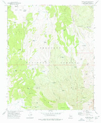
1973 Map of Munds Draw
USGS Topo · Published 1977About this map
Woodchute Mountain and the southern reach of the Black Hills dominate this high-desert landscape within the Prescott National Forest. The 1973 survey reveals a territory defined by complex topography, from the heights of Little Black Mesa down through the winding Munds Draw. The map documents a rugged water-management network essential for ranching and forestry, including the China Dam Tank, Honey Bee Tank, and the Horse Camp Tanks. Industrial activity is concentrated at the southern edge of the quadrangle, where the Haynes Shaft, a Strip Mine, and several Quarries indicate the area's mineral importance. Traces of historical movement and infrastructure are preserved through labels like the Narrow Gauge Tank and the Section House Spring, suggesting the transit corridors that once supported local mining and livestock operations.
Find a feature on this map
64 named features on this map. Tap any name to fly to it.
Don’t see what you’re looking for? This feature index may not catch every label — zoom into the map to look around manually.
Map Details
Editions of this 1973 Munds Draw Map
2 editions found
Other maps of this area

1887 · Prescott
USGS Topo · 1:250,000

1892 · Prescott
USGS Topo · 1:250,000

1905 · Jerome
USGS Topo · 1:125,000

1944 · Clarkdale
USGS Topo · 1:48,000

1944 · Mingus Mountain
USGS Topo · 1:62,500

1947 · Mingus Mtn
USGS Topo · 1:62,500

1947 · Paulden
USGS Topo · 1:62,500

1947 · Prescott
USGS Topo · 1:62,500

1948 · Prescott
USGS Topo · 1:62,500
1948 · Clarkdale
USGS Topo · 1:62,500