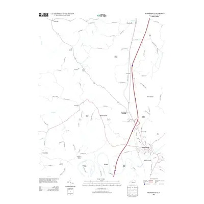
2013 Map of Munfordville
USGS Topo · Published 2013About this map
Munfordville and Woodsonville sit across from each other at a sharp bend in the Green River, anchoring this survey of central Hart County. The landscape is defined by its deep karst topography, with numerous hollows such as Possum Hollow, Dawson Hollow, and Skullbone Hollow cutting through the uplands. The Dividing Ridge separates these drainage patterns, while the Devils Backbone rises as a prominent landmark to the east of the river corridor. Small settlements like Kessinger, Priceville, and Bonnieville are connected by a network of rural routes, including the Macon Kessinger Rd and Logsdon Valley Rd. For those researching local family history, the map identifies several burial sites, including Logsdon Valley Cem and Hubbard Cem, providing specific locations for ancestral tracing in a region shaped by both its river-bend geography and its deep limestone valleys.
Find a feature on this map
98 named features on this map. Tap any name to fly to it.
Don’t see what you’re looking for? This feature index may not catch every label — zoom into the map to look around manually.
Map Details
Editions of this 2013 Munfordville Map
This is the sole edition of this map. No revisions or reprints were ever made.
Other maps of this area

1922 · Mammoth Cave
USGS Topo · 1:62,500

1923 · Mammoth Cave
USGS Topo · 1:62,500

1925 · Cub Run
USGS Topo · 1:62,500

1934 · Munfordville
USGS Topo · 1:48,000

1935 · Horse Cave
USGS Topo · 1:48,000

1937 · Munfordville
USGS Topo · 1:62,500

1938 · Horse Cave
USGS Topo · 1:62,500

1953 · Munfordville
USGS Topo · 1:24,000
1953 · Canmer
USGS Topo · 1:24,000

1954 · Evansville
USGS Topo · 1:250,000