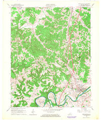
1966 Map of Munfordville
USGS Topo · Published 1968About this map
The Green River carves a deep, winding path through the southern half of this landscape, creating dramatic features like Mansfield Bend and Rush Island. This mid-century view shows Munfordville as the primary hub, situated near a strategic crossing point where the Louisville and Nashville railroad and major roadways converge. The cultural landscape is dotted with rural centers such as Priceville, Kossinger, and Bonnieville, each anchored by neighborhood landmarks like Rocky Hill Ch and Wilkerson Temple.
Find a feature on this map
40 named features on this map. Tap any name to fly to it.
Don’t see what you’re looking for? This feature index may not catch every label — zoom into the map to look around manually.
Map Details
Editions of this 1966 Munfordville Map
This is the sole edition of this map. No revisions or reprints were ever made.
Other maps of this area

1922 · Mammoth Cave
USGS Topo · 1:62,500

1923 · Mammoth Cave
USGS Topo · 1:62,500

1925 · Cub Run
USGS Topo · 1:62,500

1934 · Munfordville
USGS Topo · 1:48,000

1935 · Horse Cave
USGS Topo · 1:48,000

1937 · Munfordville
USGS Topo · 1:62,500

1938 · Horse Cave
USGS Topo · 1:62,500

1953 · Munfordville
USGS Topo · 1:24,000
1953 · Canmer
USGS Topo · 1:24,000

1954 · Evansville
USGS Topo · 1:250,000