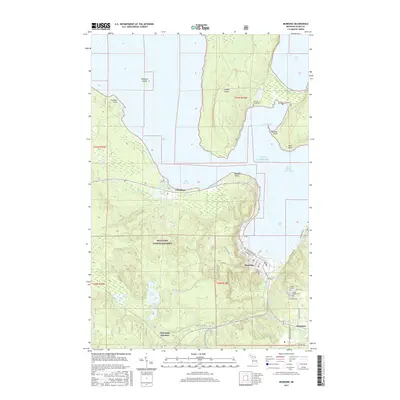
2017 Map of Munising
USGS Topo · Published 2017About this map
Munising and its surrounding Upper Peninsula shoreline are defined by the convergence of industrial history and the dramatic geography of Lake Superior. Along the coast, Bay Furnace and the neighboring settlement of Christmas sit west of the city, while the massive profile of Grand Island shelters the Grand Island Harbor Bay. The interior is characterized by the dense woodlands of the Hiawatha National Forest, where the Anna River and its tributaries like Valley Spur Cr carve through the terrain. Genealogists can locate several significant burial sites, including Williams-Powell Cem on the island and Maple Grove Cem near Wetmore. The map also documents the many cascades that punctuate the local drainage system, such as Alger Falls, Tannery Falls, and Wagner Falls south of the main township.
Find a feature on this map
57 named features on this map. Tap any name to fly to it.
Don’t see what you’re looking for? This feature index may not catch every label — zoom into the map to look around manually.
Map Details
Editions of this 2017 Munising Map
This is the sole edition of this map. No revisions or reprints were ever made.
Other maps of this area

1931 · Munising SE
USGS Topo · 1:31,680

1958 · Munising
USGS Topo · 1:62,500

1958 · Au Train
USGS Topo · 1:62,500

1958 · Wood Island
USGS Topo · 1:62,500

1958 · Marquette
USGS Topo · 1:250,000

1960 · Marquette
USGS Topo · 1:250,000

1961 · Marquette
USGS Topo · 1:250,000

1968 · Marquette
USGS Topo · 1:250,000

1983 · Munising
USGS Topo · 1:100,000
1984 · Au Sable Point
USGS Topo · 1:100,000