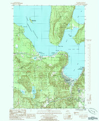
1985 Map of Munising
USGS Topo · Published 1985About this map
Grand Island and the rugged northern coastline of Michigan dominate this mid-1980s coastal survey. The city of Munising sits at the head of South Bay, serving as a gateway to the Pictured Rocks National Lakeshore and the Hiawatha National Forest. This era shows a community defined by its natural topography and seasonal tourism, featuring the Maple Mountain Ski Area and numerous cascades such as Alger Falls, Wagner Falls, and Tannery Falls. Local infrastructure is well-established, with the Munising Memorial Hospital and the Seventh-day Adventist Sch serving the residents.
Find a feature on this map
48 named features on this map. Tap any name to fly to it.
Don’t see what you’re looking for? This feature index may not catch every label — zoom into the map to look around manually.
Map Details
Editions of this 1985 Munising Map
This is the sole edition of this map. No revisions or reprints were ever made.
Other maps of this area

1931 · Munising SE
USGS Topo · 1:31,680

1958 · Munising
USGS Topo · 1:62,500

1958 · Au Train
USGS Topo · 1:62,500

1958 · Wood Island
USGS Topo · 1:62,500

1958 · Marquette
USGS Topo · 1:250,000

1960 · Marquette
USGS Topo · 1:250,000

1961 · Marquette
USGS Topo · 1:250,000

1968 · Marquette
USGS Topo · 1:250,000

1983 · Munising
USGS Topo · 1:100,000
1984 · Au Sable Point
USGS Topo · 1:100,000