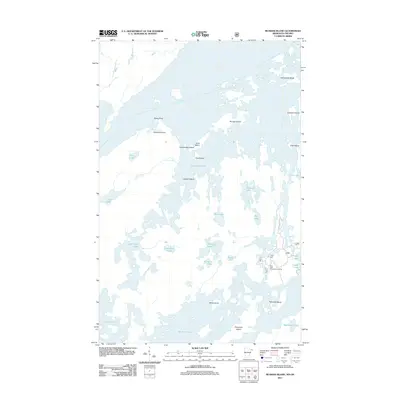
2011 Map of Munker Island
USGS Topo · Published 2011About this map
Saganaga Lake and Sea Gull Lake dominate this borderland landscape, where a dense network of water and islands defines the Minnesota-Ontario boundary. The map illustrates a complex aquatic geography including the expansive Munker Island and several smaller, distinctively named features such as Englishman Island, Gold Island, and Cooper Island. The presence of the Sea Gull River Boat Landing and the Sag Lake TRL indicates the continued importance of water-access points and portage-style paths in navigating this interconnected wilderness. Smaller interior water bodies like Hivernant Lake, Gump Lake, and Onagon Lake fill the spaces between the larger basins, while American Point and Rocky Point provide landmark navigational markers along the shorelines of the larger lakes.
Find a feature on this map
33 named features on this map. Tap any name to fly to it.
Don’t see what you’re looking for? This feature index may not catch every label — zoom into the map to look around manually.
Map Details
Editions of this 2011 Munker Island Map
This is the sole edition of this map. No revisions or reprints were ever made.
Other maps of this area

1957 · Quetico
USGS Topo · 1:250,000

1959 · Munker Island
USGS Topo · 1:24,000

1959 · Conners Island
USGS Topo · 1:24,000

1959 · Ogishkemuncie Lake
USGS Topo · 1:24,000

1959 · Gillis Lake
USGS Topo · 1:24,000

1959 · Ester Lake
USGS Topo · 1:24,000
1960 · Long Island Lake
USGS Topo · 1:24,000

1968 · Quetico
USGS Topo · 1:250,000

1976 · Saganaga Lake
USGS Topo · 1:100,000

1977 · Basswood Lake
USGS Topo · 1:100,000