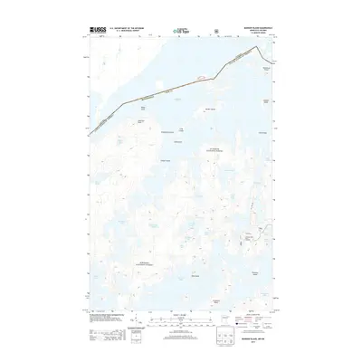
2013 Map of Munker Island
USGS Topo · Published 2013About this map
Saganaga Lake and its intricate network of islands form the international boundary between Cook County, Minnesota, and the Thunder Bay District of Ontario. This portion of the Superior National Forest is defined by a dense glacial landscape of interconnected water bodies like Sea Gull Lake and Red Rock Lake. The map reveals the logistical realities of this wilderness area, highlighting the Sea Gull River Boat Landing and the Sag Lake Trl as primary access points. Notable land features include Munker Island, American Point, and Englishman Island, which serve as markers for navigating the complex waterways. The topography is dotted with smaller, secluded basins such as Hivernant Lake and Meditation Lake, reflecting the remote, water-centric character of the Boundary Waters region in the early 21st century.
Find a feature on this map
37 named features on this map. Tap any name to fly to it.
Don’t see what you’re looking for? This feature index may not catch every label — zoom into the map to look around manually.
Map Details
Editions of this 2013 Munker Island Map
This is the sole edition of this map. No revisions or reprints were ever made.
Other maps of this area

1957 · Quetico
USGS Topo · 1:250,000

1959 · Munker Island
USGS Topo · 1:24,000

1959 · Conners Island
USGS Topo · 1:24,000

1959 · Ogishkemuncie Lake
USGS Topo · 1:24,000

1959 · Gillis Lake
USGS Topo · 1:24,000

1959 · Ester Lake
USGS Topo · 1:24,000
1960 · Long Island Lake
USGS Topo · 1:24,000

1968 · Quetico
USGS Topo · 1:250,000

1976 · Saganaga Lake
USGS Topo · 1:100,000

1977 · Basswood Lake
USGS Topo · 1:100,000