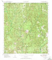
1948 Map of Munson
USGS Topo · Published 1972About this map
The Blackwater River State Forest dominates this 1948 survey, showing a landscape defined by its timber and watershed during the mid-century. Small rural hubs such as Munson, Sellersville, and Belandville appear as critical points of human settlement amidst the dense creek networks. The presence of the Munson High Sch, Spring Hill Sch, and Martins Mill Pond Sch suggests a community structure oriented around localized school districts that often served as the social glue for these forest-adjacent townships.
Find a feature on this map
69 named features on this map. Tap any name to fly to it.
Don’t see what you’re looking for? This feature index may not catch every label — zoom into the map to look around manually.
Map Details
Editions of this 1948 Munson Map
2 editions found
Other maps of this area

1920 · Milton
USGS Topo · 1:62,500

1934 · Holt
USGS Topo · 1:48,000

1934 · Harold
USGS Topo · 1:62,500

1937 · Holt
USGS Topo · 1:62,500

1937 · Harold
USGS Topo · 1:62,500

1938 · Harold
USGS Topo · 1:62,500

1941 · Milton
USGS Topo · 1:62,500

1943 · Milton
USGS Topo · 1:62,500

1943 · Jay
USGS Topo · 1:62,500

1948 · Munson
USGS Topo · 1:62,500