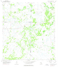
1956 Map of Murdock NE
USGS Topo · Published 1977About this map
The tri-county intersection of Manatee, Sarasota, and De Soto counties defines this mid-century Florida landscape. In a region dominated by hydrologic features, the land is marked by numerous Flowing Wells and the wandering paths of Bud Slough and Wildcat Slough. The rural character of the area is centered around the Pine Level Ch in the northeast, reflecting the small community nodes that persisted in this part of the state before modern development patterns took hold.
Find a feature on this map
9 named features on this map. Tap any name to fly to it.
Don’t see what you’re looking for? This feature index may not catch every label — zoom into the map to look around manually.
Map Details
Editions of this 1956 Murdock NE Map
4 editions found
Other maps of this area

1956 · Murdock
USGS Topo · 1:24,000

1956 · Myakka City
USGS Topo · 1:24,000

1956 · Edgeville
USGS Topo · 1:24,000

1956 · Murdock SE
USGS Topo · 1:24,000

1956 · Murdock NE
USGS Topo · 1:24,000

1956 · Limestone
USGS Topo · 1:24,000

1956 · Ft. Ogden
USGS Topo · 1:24,000

1956 · Nocatee
USGS Topo · 1:24,000

1956 · Murdock NW
USGS Topo · 1:24,000

1956 · Tampa
USGS Topo · 1:250,000