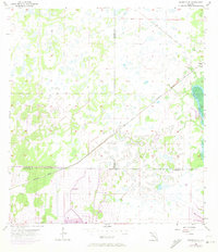
1956 Map of Murdock SE
USGS Topo · Published 1973About this map
Port Charlotte emerges as a developing urban center in this 1950s survey, with significant revisions from 1972 showing the expansion of street grids and residential subdivisions. The landscape is defined by its complex hydrology, featuring the Peace River along the eastern boundary and the engineered Cocoplum Waterway cutting through the coastal plain.
Find a feature on this map
12 named features on this map. Tap any name to fly to it.
Don’t see what you’re looking for? This feature index may not catch every label — zoom into the map to look around manually.
Map Details
Editions of this 1956 Murdock SE Map
3 editions found
Other maps of this area

1956 · Murdock
USGS Topo · 1:24,000

1956 · Murdock SE
USGS Topo · 1:24,000

1956 · Murdock NE
USGS Topo · 1:24,000

1956 · Cleveland
USGS Topo · 1:24,000

1956 · Ft. Ogden
USGS Topo · 1:24,000

1956 · Nocatee
USGS Topo · 1:24,000

1956 · Murdock NW
USGS Topo · 1:24,000

1956 · West Palm Beach
USGS Topo · 1:250,000

1956 · Tampa
USGS Topo · 1:250,000

1956 · Fort Pierce
USGS Topo · 1:250,000