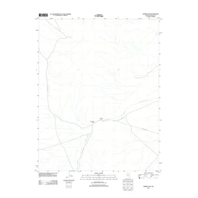
2012 Map of Murphy Gap
USGS Topo · Published 2012About this map
Wild Horse Valley occupies the center of this Lincoln County landscape, a broad basin defined by intermittent water sources and high-desert transit routes. The namesake Murphy Gap serves as a critical passage for Mail Summit Rd, which traverses the terrain from the northwest to the southeast. Vital water points such as Sharp Spring in the north and Tule Spring near the eastern margin represent the sparse but essential hydrography of this region. The drainage of Cold Springs Wash snakes through the valley, paralleled in part by the unpaved Cold Spring Rd. This map documents a quiet corner of Nevada where the geography is dictated by the availability of water and the natural corridors through the surrounding peaks.
Find a feature on this map
8 named features on this map. Tap any name to fly to it.
Don’t see what you’re looking for? This feature index may not catch every label — zoom into the map to look around manually.
Map Details
Editions of this 2012 Murphy Gap Map
This is the sole edition of this map. No revisions or reprints were ever made.
Other maps of this area

1942 · Penoyer Valley
USGS Topo · 1:125,000

1954 · Caliente
USGS Topo · 1:250,000

1959 · Caliente
USGS Topo · 1:250,000

1964 · Tempiute Mtn
USGS Topo · 1:62,500

1985 · Worthington Peak
USGS Topo · 1:24,000

1985 · Mail Summit
USGS Topo · 1:24,000
1985 · Mount Irish
USGS Topo · 1:24,000

1985 · Coal Valley Reservoir
USGS Topo · 1:24,000

1985 · Murphy Gap
USGS Topo · 1:24,000

1985 · Murphy Gap NW
USGS Topo · 1:24,000