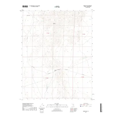
2018 Map of Murphy Gap
USGS Topo · Published 2018About this map
The Golden Gate Range dominates this portion of Lincoln County, Nevada, creating a high-altitude spine between Garden Valley and Wild Horse Valley. This 2018 survey documents the remote high-desert topography of the Great Basin, where water remains the primary driver of movement and name-giving. Reliable water sources like Sharp Spring and Tule Spring are vital markers in this arid landscape. Human passage is defined by the winding course of Mail Summit Rd, which traverses the terrain toward Murphy Gap, a natural pass through the mountains. To the south, Cold Spring Rd runs parallel to the drainage of Cold Springs Wash, illustrating how desert transit routes are dictated by the natural corridors formed by the range and its alluvial fans.
Find a feature on this map
13 named features on this map. Tap any name to fly to it.
Don’t see what you’re looking for? This feature index may not catch every label — zoom into the map to look around manually.
Map Details
Editions of this 2018 Murphy Gap Map
This is the sole edition of this map. No revisions or reprints were ever made.
Other maps of this area

1942 · Penoyer Valley
USGS Topo · 1:125,000

1954 · Caliente
USGS Topo · 1:250,000

1959 · Caliente
USGS Topo · 1:250,000

1964 · Tempiute Mtn
USGS Topo · 1:62,500

1985 · Worthington Peak
USGS Topo · 1:24,000

1985 · Mail Summit
USGS Topo · 1:24,000
1985 · Mount Irish
USGS Topo · 1:24,000

1985 · Coal Valley Reservoir
USGS Topo · 1:24,000

1985 · Murphy Gap
USGS Topo · 1:24,000

1985 · Murphy Gap NW
USGS Topo · 1:24,000