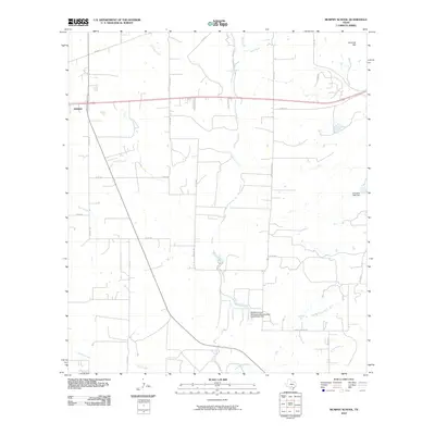
2010 Map of Murphy School
USGS Topo · Published 2010About this map
Hondo serves as the primary anchor for this Medina County landscape, which is defined by a dense network of seasonal waterways and rural transit routes. The land transitions from the elevated Schmidt Hill in the northeast toward the low-lying drainage basins of Hondo Creek, Elm Slough, and Hog Wallow Slough. This 2010 survey illustrates the regional reliance on managed water resources, evidenced by infrastructure like the Leinweber Lake Dam and the McWilliams and Wimberley Development Corporation Dam. The survey provides a clear view of the road systems connecting local homesteads and ranches, including Elstone Rd and Lower Elstone Rd, which weave through the agricultural parcels characteristic of this South Texas region. The geography here is shaped by the movement of water through the Verde Creek and Quihi Creek systems as they converge toward the south.
Find a feature on this map
29 named features on this map. Tap any name to fly to it.
Don’t see what you’re looking for? This feature index may not catch every label — zoom into the map to look around manually.
Map Details
Editions of this 2010 Murphy School Map
This is the sole edition of this map. No revisions or reprints were ever made.
Other maps of this area

1942 · Natalia
USGS Topo · 1:62,500

1954 · San Antonio
USGS Topo · 1:250,000

1956 · New Fountain
USGS Topo · 1:62,500

1957 · San Antonio
USGS Topo · 1:250,000

1964 · Riomedina
USGS Topo · 1:24,000

1964 · Castroville
USGS Topo · 1:24,000

1964 · Devine
USGS Topo · 1:24,000
1964 · Biry
USGS Topo · 1:24,000

1964 · Yancey
USGS Topo · 1:24,000
1969 · Quihi
USGS Topo · 1:24,000