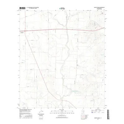
2016 Map of Murphy School
USGS Topo · Published 2016About this map
Murphy School stands as a focal point in this rural landscape of eastern Medina County, situated among the drainage networks of central Texas. The terrain is defined by the winding course of Hondo Cr, which is joined by tributaries like Verde Cr and Quihi Cr as they flow south toward the Hog Wallow Slough. To the east, Schmidt Hill provides a distinct topographic rise overlooking several water management features, including Leinweber Lake and the McWilliams and Wimberley Development Corporation Reservoir. The edge of Hondo appears at the western margin, connected to the surrounding ranchland by a web of county roads such as Elstone Rd and Paige Rd. The map illustrates a transitional environment where the open plains begin to meet the more varied creek-cut landforms characteristic of the region.
Find a feature on this map
39 named features on this map. Tap any name to fly to it.
Don’t see what you’re looking for? This feature index may not catch every label — zoom into the map to look around manually.
Map Details
Editions of this 2016 Murphy School Map
This is the sole edition of this map. No revisions or reprints were ever made.
Other maps of this area

1942 · Natalia
USGS Topo · 1:62,500

1954 · San Antonio
USGS Topo · 1:250,000

1956 · New Fountain
USGS Topo · 1:62,500

1957 · San Antonio
USGS Topo · 1:250,000

1964 · Riomedina
USGS Topo · 1:24,000

1964 · Castroville
USGS Topo · 1:24,000

1964 · Devine
USGS Topo · 1:24,000
1964 · Biry
USGS Topo · 1:24,000

1964 · Yancey
USGS Topo · 1:24,000
1969 · Quihi
USGS Topo · 1:24,000