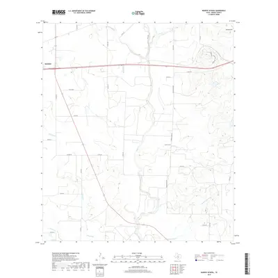
2019 Map of Murphy School
USGS Topo · Published 2019About this map
Murphy School stands as a focal point in this portion of Medina County, situated among a network of rural routes and drainage systems east of Hondo. The landscape is defined by the winding course of Hondo Creek, which is joined by several tributaries including Quihi Creek, First Creek, and Verde Creek. In the southern reaches, the terrain levels out into the seasonally wet stretches of Hog Wallow Slough and Elm Slough, while the northeast is anchored by the elevation of Schmidt Hill. This 2019 survey documents the modern road network, featuring numerous county roads like Lower Elstone Road and Paige Road that connect isolated farmsteads. The arrangement of these roads and the persistent naming of the local school reflect a long-standing rural community structure centered around the creek valleys.
Find a feature on this map
38 named features on this map. Tap any name to fly to it.
Don’t see what you’re looking for? This feature index may not catch every label — zoom into the map to look around manually.
Map Details
Editions of this 2019 Murphy School Map
This is the sole edition of this map. No revisions or reprints were ever made.
Other maps of this area

1942 · Natalia
USGS Topo · 1:62,500

1954 · San Antonio
USGS Topo · 1:250,000

1956 · New Fountain
USGS Topo · 1:62,500

1957 · San Antonio
USGS Topo · 1:250,000

1964 · Riomedina
USGS Topo · 1:24,000

1964 · Castroville
USGS Topo · 1:24,000

1964 · Devine
USGS Topo · 1:24,000
1964 · Biry
USGS Topo · 1:24,000

1964 · Yancey
USGS Topo · 1:24,000
1969 · Quihi
USGS Topo · 1:24,000