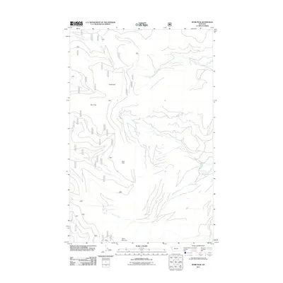
2011 Map of Murr Peak
USGS Topo · Published 2011About this map
Murr Peak and Bold Peak dominate this high-altitude landscape in Flathead County, defining a rugged Montana environment where water and stone dictate the local geography. The drainage patterns are clearly visible, as Murr Creek and its North Fork flow alongside Tamarack Creek and Briggs Creek through deep mountain cuts. This 2011 survey focuses on the natural hydrology and topographical landmarks that have guided travelers and forest managers for decades. Landmarks such as Castle Rock and Tepee Mountain provide fixed points for navigation across the drainage divides of Redmond Creek and Clear Creek. The map is a dedicated study of elevation and primary watercourses, containing no named settlements or man-made structures, instead emphasizing the pure physical layout of the wilderness terrain.
Find a feature on this map
10 named features on this map. Tap any name to fly to it.
Don’t see what you’re looking for? This feature index may not catch every label — zoom into the map to look around manually.
Map Details
Editions of this 2011 Murr Peak Map
This is the sole edition of this map. No revisions or reprints were ever made.
Other maps of this area

1956 · Wallace
USGS Topo · 1:250,000

1957 · Kalispell
USGS Topo · 1:250,000

1960 · Kalispell
USGS Topo · 1:250,000

1960 · Wallace
USGS Topo · 1:250,000

1961 · Kalispell
USGS Topo · 1:250,000

1964 · Meadow Peak
USGS Topo · 1:24,000

1964 · Mill Pocket Creek
USGS Topo · 1:24,000

1964 · Hubbart Reservoir
USGS Topo · 1:24,000
1964 · Cook Mountain
USGS Topo · 1:24,000
1964 · Shroder Creek
USGS Topo · 1:24,000