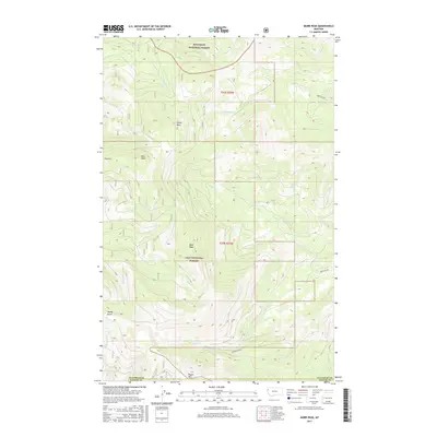
2017 Map of Murr Peak
USGS Topo · Published 2017About this map
Murr Peak and Castle Rock dominate the high-elevation terrain of this 2017 survey, which covers the boundary between the Kootenai National Forest and the Lolo National Forest. The landscape is defined by its drainage systems, with the N Fork Murr Cr and Tamarack Cr flowing through the northern half, while Redmond Cr and Clear Cr carve through the southern sections. This portion of the Salish Mountains reveals a complex network of forest roads and trails, including the notably labeled Red Gate Rd, serving as the primary infrastructure through the heavily forested mountain slopes. Near the southern edge of the sheet, the border between Flathead Co and Sanders Co runs just north of Tepee Mtn, marking a transition between administrative jurisdictions in this part of northwestern Montana.
Find a feature on this map
19 named features on this map. Tap any name to fly to it.
Don’t see what you’re looking for? This feature index may not catch every label — zoom into the map to look around manually.
Map Details
Editions of this 2017 Murr Peak Map
This is the sole edition of this map. No revisions or reprints were ever made.
Other maps of this area

1956 · Wallace
USGS Topo · 1:250,000

1957 · Kalispell
USGS Topo · 1:250,000

1960 · Kalispell
USGS Topo · 1:250,000

1960 · Wallace
USGS Topo · 1:250,000

1961 · Kalispell
USGS Topo · 1:250,000

1964 · Meadow Peak
USGS Topo · 1:24,000

1964 · Mill Pocket Creek
USGS Topo · 1:24,000

1964 · Hubbart Reservoir
USGS Topo · 1:24,000
1964 · Cook Mountain
USGS Topo · 1:24,000
1964 · Shroder Creek
USGS Topo · 1:24,000