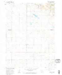
1960 Map of Murray Lake
USGS Topo · Published 1962About this map
Hull and Rose precincts define this high plains landscape as it appeared during the early 1960s, a period marked by a transition from traditional ranching to modern infrastructure development. The Stegall South Road bisects the terrain, providing a vital north-south link through a territory carved by ancient drainage systems. A notable information-gain insight is the prominence of a large Pipeline and a Radio Tower, signaling the arrival of industrial and communications utility in this rural corner of the Nebraska Panhandle. The map captures the quiet isolation of the Pleasant Hill Cem near the Hull boundary, while the northern reaches are dominated by the namesake Murray Lake and a series of deep cuts including Shoemaker Canyon and Whipple Canyon. To the south, the wide floodplain of Pumpkin Creek flows parallel to the Pumpkin Creek Road, serving as the primary geographical anchor for local land divisions.
Find a feature on this map
17 named features on this map. Tap any name to fly to it.
Don’t see what you’re looking for? This feature index may not catch every label — zoom into the map to look around manually.
Map Details
Editions of this 1960 Murray Lake Map
2 editions found
Other maps of this area

1898 · Scotts Bluff
USGS Topo · 1:125,000

1899 · Goshen Hole
USGS Topo · 1:125,000

1954 · Scottsbluff
USGS Topo · 1:250,000

1954 · Cheyenne
USGS Topo · 1:250,000

1958 · Cheyenne
USGS Topo · 1:250,000

1958 · Scottsbluff
USGS Topo · 1:250,000

1960 · Tremain
USGS Topo · 1:24,000

1960 · Mc Compsey Pass
USGS Topo · 1:24,000

1960 · Stegall
USGS Topo · 1:24,000

1960 · Murray Lake
USGS Topo · 1:24,000