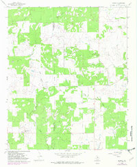
1966 Map of Murray
USGS Topo · Published 1982About this map
Oil Field operations define the landscape along the Throckmorton Co Young Co border during the mid-1960s. The small settlement of Murray serves as a local hub near where the North Fork Fish Creek and other tributaries wind through the terrain. Evidence of local industry is scattered across the sheet, with numerous Oil Wells and a Gravel Pit positioned between the drainage systems of East Kings Creek and Huffstuttle Creek. To the south, the name Coffee Flat suggests a pocket of level ground, while Matthews Hill provides a distinct topographic landmark. The map's detail is enhanced by 1981 photorevisions, which update the woodland cover and road network, such as the path of Route 578, reflecting the area's continued reliance on resource extraction and cattle ranching.
Find a feature on this map
15 named features on this map. Tap any name to fly to it.
Don’t see what you’re looking for? This feature index may not catch every label — zoom into the map to look around manually.
Map Details
Editions of this 1966 Murray Map
2 editions found
Other maps of this area

1890 · Breckenridge
USGS Topo · 1:125,000

1892 · Albany
USGS Topo · 1:125,000

1893 · Albany
USGS Topo · 1:125,000

1954 · Abilene
USGS Topo · 1:250,000

1954 · Wichita Falls
USGS Topo · 1:250,000

1958 · Wichita Falls
USGS Topo · 1:250,000

1958 · Abilene
USGS Topo · 1:250,000

1965 · Lusk
USGS Topo · 1:24,000

1965 · Throckmorton NE
USGS Topo · 1:24,000
1966 · Woodson
USGS Topo · 1:24,000