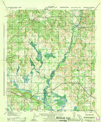
1944 Map of Muscogee
USGS Topo · Published 1944About this map
The Perdido River carves the winding border between Alabama and Florida in this wartime survey, defining a landscape of wetlands and timbered ridges. The settlement of Muscogee sits at a strategic crossing where the Frisco railroad line meets the river, while to the west, the Styx River meanders toward its confluence near Seminole. This mid-century view shows a rural economy transitioning from traditional river-and-rail dependencies to a more modern road network, including the predecessor to U.S. 90.
Find a feature on this map
20 named features on this map. Tap any name to fly to it.
Don’t see what you’re looking for? This feature index may not catch every label — zoom into the map to look around manually.
Map Details
Editions of this 1944 Muscogee Map
This is the sole edition of this map. No revisions or reprints were ever made.
Other maps of this area

1920 · Robertsdale
USGS Topo · 1:62,500

1921 · Bon Secour
USGS Topo · 1:62,500

1921 · Fort Barrancas
USGS Topo · 1:62,500

1921 · Muscogee
USGS Topo · 1:62,500

1941 · Fort Barrancas
USGS Topo · 1:62,500

1941 · Muscogee
USGS Topo · 1:62,500

1941 · Robertsdale
USGS Topo · 1:62,500

1941 · Foley
USGS Topo · 1:62,500

1943 · Robertsdale
USGS Topo · 1:62,500

1943 · Muscogee
USGS Topo · 1:62,500