
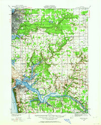
1930 Map of Muskegon
USGS Topo · Published 1960About this map
Muskegon and its industrial satellites emerge at the dawn of the 1930s, showing a landscape defined by the intersection of the Pere Marquette railroad and a dense network of schools. This survey, completed in 1928 and 1930, illustrates the expansion of Muskegon Heights and the development of Mona Beach near the Muskegon Co Landing Field. The intricate water systems of the Grand River and Spring Lake are documented with precision, revealing a labyrinth of named waterways such as Lloyds Bayou and Pottawattomie Bayou.
Find a feature on this map
91 named features on this map. Tap any name to fly to it.
Don’t see what you’re looking for? This feature index may not catch every label — zoom into the map to look around manually.
Map Details
Editions of this 1930 Muskegon Map
2 editions found
Other maps of this area

1929 · Montague
USGS Topo · 1:48,000

1929 · Holland
USGS Topo · 1:62,500

1930 · Lake Harbor
USGS Topo · 1:48,000

1932 · Holland
USGS Topo · 1:62,500

1936 · Muskegon
USGS Topo · 1:62,500

1936 · Lake Harbor
USGS Topo · 1:62,500

1945 · Ravenna
USGS Topo · 1:62,500

1954 · Milwaukee
USGS Topo · 1:250,000

1954 · Midland
USGS Topo · 1:250,000

1958 · Midland
USGS Topo · 1:250,000