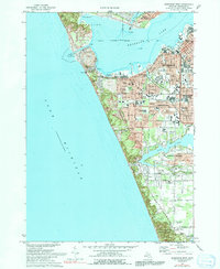
1972 Map of Muskegon West
USGS Topo · Published 1991About this map
The industrial and maritime core of Muskegon sits at the junction of Muskegon Lake and the open waters of Lake Michigan. In the early 1970s, the city’s complex transportation network is fully realized, featuring an intricate rail system including the Chesapeake and Ohio, Penn Central, and Grand Trunk Western. The map documents the residential expansion of Roosevelt Park, Norton Shores, and Muskegon Heights as they developed around established landmarks like McGraft Park. Along the shoreline, military and civil infrastructure is prominent, from the Naval Reserve Station and Coast Guard Station to the large industrial footprint of the Waterworks. To the south, the landscape shifts from the dense grid of Nelson School and Central High School neighborhoods toward the more open, recreational spaces of P J Hoffmaster State Park and Little Black Lake.
Find a feature on this map
82 named features on this map. Tap any name to fly to it.
Don’t see what you’re looking for? This feature index may not catch every label — zoom into the map to look around manually.
Map Details
Editions of this 1972 Muskegon West Map
2 editions found
Other maps of this area

1929 · Montague
USGS Topo · 1:48,000

1930 · Lake Harbor
USGS Topo · 1:48,000

1930 · Muskegon
USGS Topo · 1:62,500

1936 · Muskegon
USGS Topo · 1:62,500

1936 · Lake Harbor
USGS Topo · 1:62,500

1954 · Milwaukee
USGS Topo · 1:250,000

1958 · Milwaukee
USGS Topo · 1:250,000

1958 · Twin Lake
USGS Topo · 1:62,500

1959 · Montague
USGS Topo · 1:62,500
1972 · Muskegon West
USGS Topo · 1:24,000