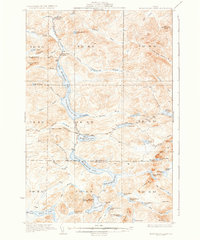
1935 Map of Musquacook Lakes
USGS Topo · Published 1935About this map
First Musquacook Lake and its sister waters form a vertical chain of glacial lakes through the heart of the North Maine Woods, as documented by surveyors F. H. Sargent and S. E. Clement in the early 1930s. This interior wilderness, spanning the boundary of Aroostook and Piscataquis counties, was defined by the logging industry's infrastructure long before modern access. The American Realty Tote Road and the California Road represent the primary overland routes through the timberlands, connecting remote outposts like Butlers Camp. Topographical features such as Clear Lake Mtn, topped by a Fire Tower, served as critical vantage points for forest fire detection. The map also records the turbulent waters of the Musquacook Stream, including the Lower Horse Race Rapids and Horse Race Rapids, which were vital corridors during the era of river-driven timber.
Find a feature on this map
72 named features on this map. Tap any name to fly to it.
Don’t see what you’re looking for? This feature index may not catch every label — zoom into the map to look around manually.
Map Details
Editions of this 1935 Musquacook Lakes Map
3 editions found
Other maps of this area

1931 · Fish River Lake
USGS Topo · 1:48,000

1931 · Mooseleuk Lake
USGS Topo · 1:48,000

1932 · Umsaskis Lake
USGS Topo · 1:48,000

1932 · Musquacook Lakes
USGS Topo · 1:48,000

1932 · Allagash Falls
USGS Topo · 1:48,000

1935 · Umsaskis Lake
USGS Topo · 1:62,500

1935 · Musquacook Lakes
USGS Topo · 1:62,500

1935 · Fish River Lake
USGS Topo · 1:62,500

1935 · Mooseleuk Lake
USGS Topo · 1:62,500

1935 · Allagash Falls
USGS Topo · 1:62,500