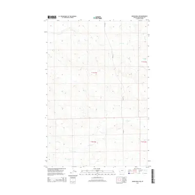
2014 Map of Musselshell NW
USGS Topo · Published 2014About this map
Howard Cr and its various tributaries define the drainage patterns across this section of Musselshell County, where the landscape is largely shaped by intermittent watercourses. In this high plains environment, the presence of Haroldson Spring stands out as a critical water source on the eastern edge of the survey. The terrain is marked by the sprawling basins of N Willow Cr and Little Wall Cr, which cut through the open country. Human passage through the area is primarily anchored by Fourmile Rd, which provides a north-south corridor through the center of the region. This 2014 survey documents the enduring physical character of the land as it remains largely undeveloped, preserving the exact water and road networks utilized by local ranchers and land managers.
Find a feature on this map
9 named features on this map. Tap any name to fly to it.
Don’t see what you’re looking for? This feature index may not catch every label — zoom into the map to look around manually.
Map Details
Editions of this 2014 Musselshell NW Map
This is the sole edition of this map. No revisions or reprints were ever made.
Other maps of this area

1954 · Roundup
USGS Topo · 1:250,000

1958 · Roundup
USGS Topo · 1:250,000

1963 · Kelley
USGS Topo · 1:24,000

1963 · Musselshell
USGS Topo · 1:24,000
1963 · Akers Ranch
USGS Topo · 1:24,000

1963 · Musselshell NW
USGS Topo · 1:24,000
1963 · Mud Spring
USGS Topo · 1:24,000

1963 · Delphia
USGS Topo · 1:24,000

1986 · Crowley Dam
USGS Topo · 1:24,000
1986 · Big Wall East
USGS Topo · 1:24,000