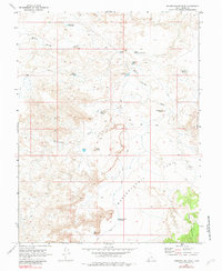
1968 Map of Mussentuchit Flat
USGS Topo · Published 1983About this map
Mussentuchit Flat defines this arid landscape in Emery County, where a complex network of ephemeral drainages and vital water catchments supported ranching and transit in the late 1960s. The topography is dominated by dramatic elevations like Deadman Peak and Hebes Mountain, with the distinctive Twin Peaks rising near the center of the survey. The distribution of small-scale water infrastructure, including Blue Flat Reservoir, Dinner Pond, and Reeds Pond, reveals the essential role of water management in this high-desert environment. A web of Jeep Trails provides the primary means of navigating between these points, connecting the low-lying Mussentuchit Wash to higher ground at Red Point and the slopes of Cedar Mountain. These trails often follow the natural contours of the wash systems, such as Willow Springs Wash, illustrating the continued reliance on geographic pathways established long before modern road development.
Find a feature on this map
21 named features on this map. Tap any name to fly to it.
Don’t see what you’re looking for? This feature index may not catch every label — zoom into the map to look around manually.
Map Details
Editions of this 1968 Mussentuchit Flat Map
3 editions found
Other maps of this area

1885 · Fish Lake
USGS Topo · 1:250,000

1896 · Fish Lake
USGS Topo · 1:250,000

1925 · Acord Lakes
USGS Topo · 1:62,500

1953 · Emery 4 NE
USGS Topo · 1:24,000

1953 · Emery 4 SE
USGS Topo · 1:24,000

1953 · Emery 1 SE
USGS Topo · 1:24,000

1956 · Salina
USGS Topo · 1:250,000

1960 · Salina
USGS Topo · 1:250,000

1962 · Salina
USGS Topo · 1:250,000
1968 · Solomons Temple
USGS Topo · 1:24,000