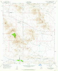
1958 Map of Mustang Mountains
USGS Topo · Published 1963About this map
Babocomari Ranch and the expansive San Ignacio del Babocomari land grant dominate the southern portion of this high-desert landscape during the late 1950s. The terrain transitions from the high peaks of the Mustang Mountains, including Mustang Peak and Mt Bruce, down into the broad corridor of Rain Valley. This area shows a cattle-ranching economy in mid-century Arizona, with established outposts like Sands Ranch, Rain Valley Ranch, and Sands West Camp dotting the map. Infrastructure for transport and industry is evident where the Southern Pacific railroad runs parallel to the Babocomari River, passing near a Gravel Pit and through the settlement of Lyle. The northern boundary touches the Coronado National Forest near the Whetstone Mountains, where water sources like Cottonwood Spring and Mescal Spring were vital for both the local livestock and the occasional Jeep Trail traveler.
Find a feature on this map
29 named features on this map. Tap any name to fly to it.
Don’t see what you’re looking for? This feature index may not catch every label — zoom into the map to look around manually.
Map Details
Editions of this 1958 Mustang Mountains Map
Other maps of this area

1904 · Patagonia
USGS Topo · 1:125,000

1905 · Patagonia
USGS Topo · 1:125,000

1915 · Benson
USGS Topo · 1:125,000

1926 · Whetstone
USGS Topo · 1:62,500

1932 · Elgin
USGS Topo · 1:62,500

1938 · Huachuca
USGS Topo · 1:62,500

1940 · Elgin
USGS Topo · 1:62,500

1943 · Benson
USGS Topo · 1:125,000

1947 · Elgin
USGS Topo · 1:62,500

1948 · Elgin
USGS Topo · 1:24,000