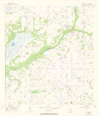
1956 Map of Myakka City
USGS Topo · Published 1973About this map
The Myakka River defines the drainage of this interior section of Manatee County, winding through a complex landscape of wetlands and prairie just as development began to touch the rural landscape. In the northeastern corner, the small grid of Myakka City serves as the primary settlement center, while the unincorporated area of Parmalee sits further west. The topography is dominated by hydrological features like the Tatum Sawgrass marsh and several named sloughs and gullies, including Tatum Gully and Mossy Island Slough. Genealogy and local history researchers will find the Sardis Cem located south of the river, along with notable water bodies such as Cason Lake, Lettuce Lake, and Roxy Pond. The southwestern portion of the sheet shows the beginnings of the State Park, documenting the preservation of the river corridor amid the scattered homesteads and dirt roads that characterized the region in the mid-1950s.
Find a feature on this map
16 named features on this map. Tap any name to fly to it.
Don’t see what you’re looking for? This feature index may not catch every label — zoom into the map to look around manually.
Map Details
Editions of this 1956 Myakka City Map
3 editions found
Other maps of this area

1944 · Lower Myakka Lake
USGS Topo · 1:31,680

1944 · Verna
USGS Topo · 1:31,680

1944 · Miakka
USGS Topo · 1:31,680

1956 · Myakka City
USGS Topo · 1:24,000

1956 · Edgeville
USGS Topo · 1:24,000

1956 · Myakka City NW
USGS Topo · 1:24,000

1956 · Murdock NE
USGS Topo · 1:24,000

1956 · Myakka Head
USGS Topo · 1:24,000

1956 · Murdock NW
USGS Topo · 1:24,000

1956 · Tampa
USGS Topo · 1:250,000