
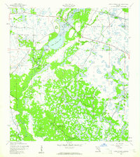
1944 Map of Lower Myakka Lake
USGS Topo · Published 1944About this map
Lower Myakka Lake and the meandering Myakka River dominate this mid-century landscape in Sarasota County. The map captures a transition from wild Florida marshland to established conservation, centered on the Myakka State Forest and Park. Inland settlements and isolated outposts like Shiney Town, Harris Camp, and Fortners Camp suggest a rugged, river-dependent existence before modern development reshaped the region. Significant infrastructure includes the Atlantic Coast Line railroad and Sugar Bowl Road, which slice through the wetlands near Honore. Notable landmarks such as Deep Hole and an Aero Bn beacon reflect the specialized use of this terrain, while the division into precincts highlights the early political organization of the rural Florida interior.
Find a feature on this map
20 named features on this map. Tap any name to fly to it.
Don’t see what you’re looking for? This feature index may not catch every label — zoom into the map to look around manually.
Map Details
Editions of this 1944 Lower Myakka Lake Map
2 editions found
Other maps of this area

1943 · Laurel
USGS Topo · 1:24,000

1944 · Myakka River
USGS Topo · 1:31,680

1944 · Laurel
USGS Topo · 1:31,680

1944 · Venice
USGS Topo · 1:31,680

1944 · Miakka
USGS Topo · 1:31,680

1947 · Bee Ridge
USGS Topo · 1:24,000

1956 · Murdock
USGS Topo · 1:24,000

1956 · Myakka City
USGS Topo · 1:24,000

1956 · Murdock NW
USGS Topo · 1:24,000

1956 · Tampa
USGS Topo · 1:250,000