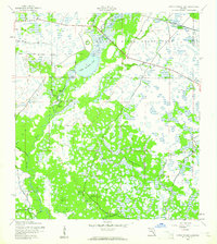
1944 Map of Lower Myakka Lake
USGS Topo · Published 1961About this map
Myakka River State Park dominates this mid-century landscape, capturing the preserved wetlands and hammocks of Sarasota and Manatee counties during World War II. The Myakka River winds through the region, widening into Lower Myakka Lake and creating unique features like the Deep Hole and Vanderipe Slough. The presence of Harris Camp, Fortners Camp, and Shiney Town along the river suggests localized fishing or recreational settlements within the river's floodplains. While much of the area remained undeveloped conservation land, the Atlantic Coast Line railroad skirts the northern boundary, providing a vital transportation link through the Florida interior. This survey, compiled from 1942 aerial photography, documents the original boundaries and hydrological patterns of one of Florida’s oldest state parks before significant modern alterations.
Find a feature on this map
10 named features on this map. Tap any name to fly to it.
Don’t see what you’re looking for? This feature index may not catch every label — zoom into the map to look around manually.
Map Details
Editions of this 1944 Lower Myakka Lake Map
2 editions found
Other maps of this area

1943 · Laurel
USGS Topo · 1:24,000

1944 · Lower Myakka Lake
USGS Topo · 1:31,680

1944 · Myakka River
USGS Topo · 1:31,680

1944 · Laurel
USGS Topo · 1:31,680

1944 · Venice
USGS Topo · 1:31,680

1944 · Miakka
USGS Topo · 1:31,680

1947 · Bee Ridge
USGS Topo · 1:24,000

1956 · Murdock
USGS Topo · 1:24,000

1956 · Myakka City
USGS Topo · 1:24,000

1956 · Murdock NW
USGS Topo · 1:24,000