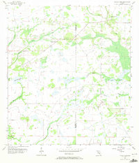
1956 Map of Myakka Head
USGS Topo · Published 1972About this map
The confluence of Florida's swampy interior and early-century ranching life is visible in the network of seasonal drainages and isolated settlements surrounding Myakka Head. This 1950s survey shows the Manatee and Hardee County line as it crosses a landscape defined by meandering waterways like Hog Town Slough and Myakka River. The presence of the New Zion Ch near West Fork Horse Creek indicates the social anchors of this sparsely populated rural area, where the economy was tied to the land long before modern development reached this part of the interior. The map captures the intricate drainage patterns of the Elder Branch, Cypress Branch, and Wingate Creek, showing how water dictated the placement of early roads and the boundaries of Myakka Head Park.
Find a feature on this map
14 named features on this map. Tap any name to fly to it.
Don’t see what you’re looking for? This feature index may not catch every label — zoom into the map to look around manually.
Map Details
Editions of this 1956 Myakka Head Map
4 editions found
Other maps of this area

1955 · Ft. Green
USGS Topo · 1:24,000

1956 · Ona
USGS Topo · 1:24,000

1956 · Myakka City
USGS Topo · 1:24,000

1956 · Edgeville
USGS Topo · 1:24,000

1956 · Myakka City NW
USGS Topo · 1:24,000

1956 · Myakka Head
USGS Topo · 1:24,000

1956 · Limestone
USGS Topo · 1:24,000

1956 · Duette
USGS Topo · 1:24,000

1956 · Keentown
USGS Topo · 1:24,000

1956 · Tampa
USGS Topo · 1:250,000