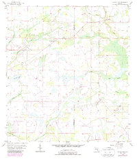
1956 Map of Myakka Head
USGS Topo · Published 1987About this map
Myakka Head sits at the center of this mid-century Florida interior, where the Myakka River begins its course through a landscape defined by seasonal sloughs and intricate creek branches. The 1950s survey captures the region along the Manatee and Hardee county line, showing a pattern of sparse settlement and open terrain before the expansion of modern citrus groves and intensive agriculture. To the north, the New Zion Ch serves as a local landmark near the West Fork Horse Creek, while the Myakka Head Park area provides a focal point for the small community. Numerous watercourses, including Wingate Creek, Hog Town Slough, and Long Creek, create a complex drainage network that dominates the topography. Revisions from the 1980s illustrate changing woodland cover, highlighting the slow shift in land use in this part of Florida's cattle and timber country.
Find a feature on this map
14 named features on this map. Tap any name to fly to it.
Don’t see what you’re looking for? This feature index may not catch every label — zoom into the map to look around manually.
Map Details
Editions of this 1956 Myakka Head Map
4 editions found
Other maps of this area

1955 · Ft. Green
USGS Topo · 1:24,000

1956 · Ona
USGS Topo · 1:24,000

1956 · Myakka City
USGS Topo · 1:24,000

1956 · Edgeville
USGS Topo · 1:24,000

1956 · Myakka City NW
USGS Topo · 1:24,000

1956 · Myakka Head
USGS Topo · 1:24,000

1956 · Limestone
USGS Topo · 1:24,000

1956 · Duette
USGS Topo · 1:24,000

1956 · Keentown
USGS Topo · 1:24,000

1956 · Tampa
USGS Topo · 1:250,000