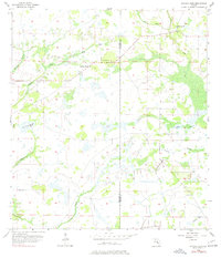
1956 Map of Myakka Head
USGS Topo · Published 1977About this map
Myakka Head and its surrounding wetlands occupy this mid-century landscape along the border of Manatee and Hardee counties. The area is defined by an intricate network of waterways, with the Myakka River and Wingate Creek winding through the western terrain, while the West Fork joins Horse Creek in the northeast. This topography shows the inland Florida interior prior to extensive modern development, characterized by numerous marshes, sloughs, and named drainage branches like Elder Branch and Cypress Branch. Cultural landmarks are sparse but significant for local history, including the New Zion Ch and the small clearing at Myakka Head Park. The map documents a rural era when 64 served as the primary east-west artery through a landscape of palmetto and pine, providing a clear record of the region's natural drainage patterns before later land modifications.
Find a feature on this map
17 named features on this map. Tap any name to fly to it.
Don’t see what you’re looking for? This feature index may not catch every label — zoom into the map to look around manually.
Map Details
Editions of this 1956 Myakka Head Map
4 editions found
Other maps of this area

1955 · Ft. Green
USGS Topo · 1:24,000

1956 · Ona
USGS Topo · 1:24,000

1956 · Myakka City
USGS Topo · 1:24,000

1956 · Edgeville
USGS Topo · 1:24,000

1956 · Myakka City NW
USGS Topo · 1:24,000

1956 · Myakka Head
USGS Topo · 1:24,000

1956 · Limestone
USGS Topo · 1:24,000

1956 · Duette
USGS Topo · 1:24,000

1956 · Keentown
USGS Topo · 1:24,000

1956 · Tampa
USGS Topo · 1:250,000