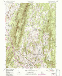
1953 Map of Myersville
USGS Topo · Published 1985About this map
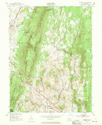
South Mountain dominates the center of this terrain, forming a high ridge that separates Washington and Frederick counties. The landscape transitions from the agricultural valleys near Myersville and Wolfsville to the protected woodlands of the South Mountain Environmental Area. Cultural development is concentrated along the base of the ridges, featuring landmarks like St Marks Ch and Grossnickle Ch, while the higher elevations are marked by the Washington Monument State Park and recreational sites like the Girl Scout Camp. To the east, the map captures the lower slopes of Catoctin Mountain and the unique geography of the Buzzard Flats, showing a mid-century Maryland landscape where small hamlets like Ellerton and Highland were connected by winding rural roads long before significant modern suburbanization.
Find a feature on this map
43 named features on this map. Tap any name to fly to it.
Don’t see what you’re looking for? This feature index may not catch every label — zoom into the map to look around manually.
Map Details
Editions of this 1953 Myersville Map
6 editions found
Other maps of this area

1884 · Harpers Ferry
USGS Topo · 1:125,000

1891 · Harpers Ferry
USGS Topo · 1:125,000

1893 · Frederick
USGS Topo · 1:125,000

1893 · Harpers Ferry
USGS Topo · 1:125,000

1894 · Frederick
USGS Topo · 1:125,000

1908 · Middletown
USGS Topo · 1:48,000

1908 · Ijamsville
USGS Topo · 1:62,500

1909 · Ijamsville
USGS Topo · 1:62,500

1909 · Hagerstown
USGS Topo · 1:48,000

1910 · Antietam
USGS Topo · 1:62,500