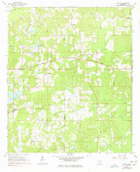
1964 Map of Myrick
USGS Topo · Published 1978About this map
Bogue Homo and its many tributaries, including Pool Creek and Brushy Creek, define this rural landscape along the border of Jones and Wayne Counties. The mid-century settlement pattern is anchored by the community of Myrick and smaller clusters at Lightsey and Pineview. Spiritual and communal life in the 1960s was centered on numerous country churches such as Palestine Ch, Faith Chapel, and Lees Chapel, while family legacies are preserved at the Dennis Blackledge Cem and Sellers Cem.
Find a feature on this map
35 named features on this map. Tap any name to fly to it.
Don’t see what you’re looking for? This feature index may not catch every label — zoom into the map to look around manually.
Map Details
Editions of this 1964 Myrick Map
3 editions found
Other maps of this area

1953 · Hattiesburg
USGS Topo · 1:250,000

1958 · Hattiesburg
USGS Topo · 1:250,000

1964 · Heidelberg SW
USGS Topo · 1:24,000

1964 · Sandersville
USGS Topo · 1:24,000

1964 · Eucutta
USGS Topo · 1:24,000

1964 · Laurel East
USGS Topo · 1:24,000

1964 · Myrick
USGS Topo · 1:24,000

1964 · Strengthford
USGS Topo · 1:24,000

1964 · Whistler
USGS Topo · 1:24,000

1964 · Lanham
USGS Topo · 1:24,000