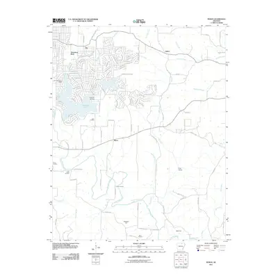
2011 Map of Myron
USGS Topo · Published 2011About this map
Horseshoe Bend anchors the northwestern corner of this Izard County landscape, showcasing an intricate network of residential streets and recreational features like Diamond Lake and the Horseshoe Bend Airport. The terrain transitions from these modern developments into the more rural, sparsely populated areas around Myron and Day. Genealogists will find a high density of burial sites across the quadrangle, including the Hills Chapel Cemetery, Godwin Cemetery, and Bates Cemetery, which serve as markers for long-standing family ties in the region. The drainage patterns of the Strawberry River and its various tributaries, such as Hars Creek and Bens Creek, define the natural topography and have historically influenced the location of these early cemeteries and farmsteads. To the south, prominent elevations like Davidson Hill and Baker Hill rise above the river valley, while King Hollow provides a glimpse into the localized geography of this Ozark foothills environment.
Find a feature on this map
117 named features on this map. Tap any name to fly to it.
Don’t see what you’re looking for? This feature index may not catch every label — zoom into the map to look around manually.
Map Details
Editions of this 2011 Myron Map
This is the sole edition of this map. No revisions or reprints were ever made.
Other maps of this area

1950 · Salem
USGS Topo · 1:62,500

1951 · Salem
USGS Topo · 1:62,500

1951 · Melbourne
USGS Topo · 1:62,500

1957 · Poplar Bluff
USGS Topo · 1:250,000

1959 · Poplar Bluff
USGS Topo · 1:250,000

1960 · Poplar Bluff
USGS Topo · 1:250,000
1961 · Evening Shade
USGS Topo · 1:24,000

1962 · Stuart
USGS Topo · 1:24,000

1962 · Ash Flat
USGS Topo · 1:24,000
1962 · Sidney
USGS Topo · 1:24,000