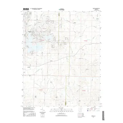
2017 Map of Myron
USGS Topo · Published 2017About this map
The Strawberry River meanders across this northern Arkansas landscape, defining the topography between the small settlements of Myron, Ballard, and Franklin. In the western portion of the quadrangle, the planned community of Horseshoe Bend surrounds substantial water bodies including Crown Lake and Diamond Lake, showing the transition from traditional Ozark farming land to a developed residential and recreational hub. Family and community heritage is anchored by several rural burying grounds such as Hills Chapel Cem, Baker Cem, Godwin Cem, and Bates Cem. High points like Davidson Hill and Baker Hill overlook a network of creek drainages including Bens Creek and Hars Cr, while the crossing of the Izard and Sharp County line marks the eastern boundary of the survey. The map records a mix of modern street layouts in the resort area contrasted with the older hollows and ridges of the surrounding countryside.
Find a feature on this map
157 named features on this map. Tap any name to fly to it.
Don’t see what you’re looking for? This feature index may not catch every label — zoom into the map to look around manually.
Map Details
Editions of this 2017 Myron Map
This is the sole edition of this map. No revisions or reprints were ever made.
Other maps of this area

1950 · Salem
USGS Topo · 1:62,500

1951 · Salem
USGS Topo · 1:62,500

1951 · Melbourne
USGS Topo · 1:62,500

1957 · Poplar Bluff
USGS Topo · 1:250,000

1959 · Poplar Bluff
USGS Topo · 1:250,000

1960 · Poplar Bluff
USGS Topo · 1:250,000
1961 · Evening Shade
USGS Topo · 1:24,000

1962 · Stuart
USGS Topo · 1:24,000

1962 · Ash Flat
USGS Topo · 1:24,000
1962 · Sidney
USGS Topo · 1:24,000