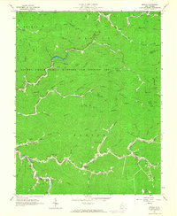
1963 Map of Myrtle
USGS Topo · Published 1964About this map
The Laurel Creek Public Hunting and Fishing Area dominates the central landscape of this Mingo County region, a terrain defined by the complex drainage of Pigeon Creek and Twelvepole Creek. In the early 1960s, the local economy is evidenced by infrastructure such as an Air Shaft, a Mine, and several prominent waste sites labeled as Mike Dump and Mine Dump near the community of Scarlet. The human geography is deeply rooted in narrow hollows, where family history is preserved in numerous small burial grounds like Lackey Cem, Newsome Cem, and Alexanders Cem.
Find a feature on this map
77 named features on this map. Tap any name to fly to it.
Don’t see what you’re looking for? This feature index may not catch every label — zoom into the map to look around manually.
Map Details
Editions of this 1963 Myrtle Map
2 editions found
Other maps of this area

1887 · Warfield
USGS Topo · 1:125,000

1891 · Warfield
USGS Topo · 1:125,000

1909 · Matewan
USGS Topo · 1:48,000

1910 · Holden
USGS Topo · 1:48,000

1910 · Naugatuck
USGS Topo · 1:48,000

1912 · Naugatuck
USGS Topo · 1:62,500

1912 · Holden
USGS Topo · 1:62,500

1915 · Williamson
USGS Topo · 1:48,000

1915 · Naugatuck
USGS Topo · 1:48,000

1915 · Matewan
USGS Topo · 1:48,000