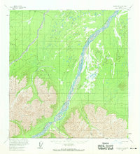
1960 Map of Nabesna B-2
USGS Topo · Published 1969About this map
The braided channels of the Chisana River dominate this interior Alaskan landscape, which was photogrammetrically mapped using mid-1950s aerial photography. The remote terrain is marked by essential seasonal transportation routes, including a Winter Trail and a Tractor route that navigate the river valley and surrounding highlands. Of particular interest to local historians is the recorded location of King City (Site), situated on the banks of the river at the foot of the mountains. The presence of several drainages such as Brian Creek and Sheep Creek suggests a reliance on natural watercourses for navigation and geography in this largely unsurveyed region. This 1960 field annotation preserves the layout of the land before modern development, showing the intersection of vital trails with the ever-shifting riverbed.
Find a feature on this map
10 named features on this map. Tap any name to fly to it.
Don’t see what you’re looking for? This feature index may not catch every label — zoom into the map to look around manually.
Map Details
Editions of this 1960 Nabesna B-2 Map
2 editions found
Other maps of this area

1950 · Nabesna
USGS Topo · 1:250,000

1951 · Nabesna
USGS Topo · 1:250,000

1954 · Nabesna C-3
USGS Topo · 1:63,360

1955 · Nabesna C-1
USGS Topo · 1:63,360

1955 · Nabesna C-2
USGS Topo · 1:63,360

1955 · Nabesna C-3
USGS Topo · 1:63,360

1959 · Nabesna A-1
USGS Topo · 1:63,360

1960 · Nabesna A-3
USGS Topo · 1:63,360

1960 · Nabesna A-2
USGS Topo · 1:63,360

1960 · Nabesna B-2
USGS Topo · 1:63,360