
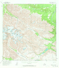
1959 Map of Nabesna A-1
USGS Topo · Published 1965About this map
Beaver Creek and the Alaska Yukon border define this high-altitude landscape as it was documented in the late 1950s. The terrain is dominated by the massive Carl Glacier to the west, feeding a complex drainage system that includes Snag Creek, East Fork, and the winding Baultoff Creek. This remote stretch of the United States Canada boundary shows the practicalities of wilderness travel, with the Winter Trail cutting through the northern section and the Eureka Gulch Trail navigating the southeast near Braye Lakes. A single Cabin and a remote Landing Strip near the confluence of the Little Horsfeld Creek and Beaver Creek represent the only signs of human infrastructure, highlighting the extreme isolation of this frontier region during the mid-century surveying era.
Find a feature on this map
26 named features on this map. Tap any name to fly to it.
Don’t see what you’re looking for? This feature index may not catch every label — zoom into the map to look around manually.
Map Details
Editions of this 1959 Nabesna A-1 Map
2 editions found
Other maps of this area

1950 · Nabesna
USGS Topo · 1:250,000

1951 · McCarthy
USGS Topo · 1:250,000

1951 · Nabesna
USGS Topo · 1:250,000

1959 · McCarthy D-1
USGS Topo · 1:63,360

1959 · McCarthy D-2
USGS Topo · 1:63,360

1960 · Nabesna A-2
USGS Topo · 1:63,360

1960 · Nabesna B-2
USGS Topo · 1:63,360

1960 · Nabesna
USGS Topo · 1:250,000

1960 · Nabesna B-1
USGS Topo · 1:63,360

1960 · McCarthy
USGS Topo · 1:250,000