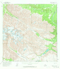
1959 Map of Nabesna A-1
USGS Topo · Published 1971About this map
The Nutzotin Mountains dominate this high-altitude landscape along the remote Alaska Yukon border. Surveyed in the late 1950s, the map reveals a wilderness primarily defined by glacial topography and an intricate drainage network. Water travels through high-elevation valleys via Beaver Creek and Bauthoff Creek, while the presence of a solitary Cabin and a remote Landing Strip near Horsfeld Creek suggests the seasonal outposts of trappers or early bush pilots. A long Winter Trail cuts across the northern reaches, following the contours of Cottonwood Creek and Anaconda Creek. This route represents a vital link in a region where travel depended entirely on seasonal conditions and the natural passes of the mountains, such as Braye Pass. The map serves as a primary record of the topographic character of this subarctic frontier before modern infrastructure reached the interior.
Find a feature on this map
24 named features on this map. Tap any name to fly to it.
Don’t see what you’re looking for? This feature index may not catch every label — zoom into the map to look around manually.
Map Details
Editions of this 1959 Nabesna A-1 Map
2 editions found
Other maps of this area

1950 · Nabesna
USGS Topo · 1:250,000

1951 · McCarthy
USGS Topo · 1:250,000

1951 · Nabesna
USGS Topo · 1:250,000

1959 · McCarthy D-1
USGS Topo · 1:63,360

1959 · McCarthy D-2
USGS Topo · 1:63,360

1959 · Nabesna A-1
USGS Topo · 1:63,360

1960 · Nabesna A-2
USGS Topo · 1:63,360

1960 · Nabesna B-2
USGS Topo · 1:63,360

1960 · Nabesna
USGS Topo · 1:250,000

1960 · Nabesna B-1
USGS Topo · 1:63,360