
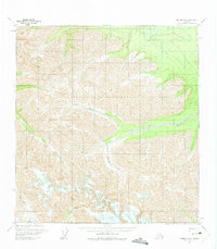
1960 Map of Nabesna B-3
USGS Topo · Published 1966About this map
Antler Creek and Stuver Creek dominate this 1960 landscape, revealing the drainage patterns of a high-altitude wilderness before extensive modern development. The map details a seasonal transportation network essential for Arctic travel, including the Winter Trail in the northeast and a Tractor Trail near the southern edge. These corridors suggest how early twentieth-century explorers and miners navigated the terrain. Notable landmarks like Cooper Pass and the confluence of Lick Creek provide critical reference points in an area defined by glacial valleys and steep divides. The presence of Ninemile Creek and Canyon Creek underscores the complex waterway system that dictates movement through this part of the Alaska Range.
Find a feature on this map
11 named features on this map. Tap any name to fly to it.
Don’t see what you’re looking for? This feature index may not catch every label — zoom into the map to look around manually.
Map Details
Editions of this 1960 Nabesna B-3 Map
2 editions found
Other maps of this area

1950 · Nabesna
USGS Topo · 1:250,000

1951 · Nabesna
USGS Topo · 1:250,000

1954 · Nabesna C-3
USGS Topo · 1:63,360

1955 · Nabesna C-2
USGS Topo · 1:63,360

1955 · Nabesna C-3
USGS Topo · 1:63,360

1959 · Nabesna A-4
USGS Topo · 1:63,360

1960 · Nabesna B-4
USGS Topo · 1:63,360

1960 · Nabesna A-3
USGS Topo · 1:63,360

1960 · Nabesna A-2
USGS Topo · 1:63,360

1960 · Nabesna B-2
USGS Topo · 1:63,360