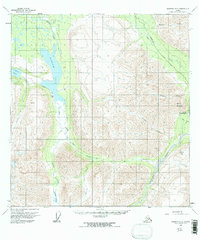
1960 Map of Nabesna B-5
USGS Topo · Published 1967About this map
Tanada Lodge serves as a lone human outpost on the western edge of this interior landscape, positioned near the shores of Tanada Lake. The terrain is defined by dramatic elevation changes, rising from the waters of Copper Lake and the braided channels of Jacksina Creek toward the heights of White Mountain and Gold Hill. Access through this territory in the late 1950s relied on a network of unpaved routes, including a Tractor Trail and a Pack Trail that crosses a high Pass. Evidence of early industrial interest appears at a Mine near the settlement of Nabesna, where the confluence of several tributaries like Wait Creek and Canyon Creek carve deep through the mountain blocks. This 1960 field-annotated survey captures the area before modern infrastructure, when Cabins along Jack Creek were some of the few established structures in the wilderness.
Find a feature on this map
23 named features on this map. Tap any name to fly to it.
Don’t see what you’re looking for? This feature index may not catch every label — zoom into the map to look around manually.
Map Details
Editions of this 1960 Nabesna B-5 Map
3 editions found
Other maps of this area

1948 · Nabesna C-6
USGS Topo · 1:63,360

1950 · Nabesna
USGS Topo · 1:250,000

1951 · Nabesna
USGS Topo · 1:250,000

1952 · Nabesna C-6
USGS Topo · 1:63,360

1957 · Nabesna C-5
USGS Topo · 1:63,360

1959 · Nabesna A-6
USGS Topo · 1:63,360

1959 · Nabesna A-4
USGS Topo · 1:63,360

1959 · Nabesna A-5
USGS Topo · 1:63,360

1960 · Nabesna B-4
USGS Topo · 1:63,360

1960 · Nabesna B-5
USGS Topo · 1:63,360