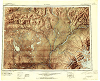
1960 Map of Nabesna B-6
USGS Topo · Published 1966About this map
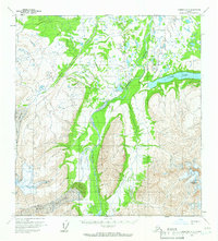
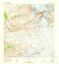
Copper River braids through this glacial landscape, serving as the central drainage for the massive ice fields and steep slopes of the eastern Alaska Range. In the early 1960s, the region remained largely undeveloped, characterized by the movement of ice from West Glacier and Drop Glacier. The presence of a solitary Tractor Trail cutting through the northern portion of the map indicates the limited reach of mechanical transport in this wilderness at the time of the survey. To the east, Copper Lake sits at the base of the high peaks, including the prominent Tanada Peak. This map records a landscape shaped by ice and water, where Drop Creek and other tributaries descend from high elevations to join the winding river valley below.
Find a feature on this map
7 named features on this map. Tap any name to fly to it.
Don’t see what you’re looking for? This feature index may not catch every label — zoom into the map to look around manually.
Map Details
Editions of this 1960 Nabesna B-6 Map
2 editions found

Other maps of this area
1948 · Nabesna C-6
USGS Topo · 1:63,360
1949 · Gulkana C-1
USGS Topo · 1:63,360
1950 · Nabesna
USGS Topo · 1:250,000
1951 · Gulkana
USGS Topo · 1:250,000
1951 · Nabesna
USGS Topo · 1:250,000

1952 · Nabesna C-6
USGS Topo · 1:63,360
1952 · Gulkana C-1
USGS Topo · 1:63,360

1957 · Nabesna C-5
USGS Topo · 1:63,360
1959 · Gulkana B-1
USGS Topo · 1:63,360
1959 · Gulkana A-1
USGS Topo · 1:63,360