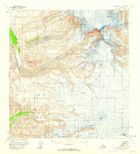
1959 Map of Gulkana A-1
USGS Topo · Published 1964About this map
Mount Sanford dominates this landscape, rising as a massive peak amid a complex system of ice and river drainages. Compiled from mid-century aerial photography, the survey documents an era of active glacial activity where the Sanford Glacier and Dadina Glacier carve deep paths through the high terrain. The drainage patterns are clearly defined by the Sanford River and the Dadina River, which carry meltwater away from the frozen heights of the Wrangell Mountains. To the south, Mount Wrangell and Mt Zanetti stand as prominent landmarks, while Nathlie Mountain sits near the western edge of the ice fields. This map provides a technical look at the land's surface before later twentieth-century changes, specifically showing the vast reaches of the Chiehokna Glacier and Chetaslina Glacier as they were shaped in the late 1950s.
Find a feature on this map
11 named features on this map. Tap any name to fly to it.
Don’t see what you’re looking for? This feature index may not catch every label — zoom into the map to look around manually.
Map Details
Editions of this 1959 Gulkana A-1 Map
2 editions found
Other maps of this area

1949 · Gulkana B-2
USGS Topo · 1:63,360

1950 · Nabesna
USGS Topo · 1:250,000

1951 · McCarthy
USGS Topo · 1:250,000

1951 · Gulkana
USGS Topo · 1:250,000

1951 · Nabesna
USGS Topo · 1:250,000

1952 · Valdez
USGS Topo · 1:250,000

1952 · Gulkana B-2
USGS Topo · 1:63,360

1959 · Gulkana B-1
USGS Topo · 1:63,360

1959 · Valdez D-2
USGS Topo · 1:63,360
1959 · Gulkana A-2
USGS Topo · 1:63,360