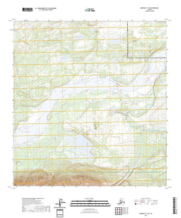
2023 Map of Nabesna C-3 SW
USGS Topo · Published 2023About this map
The Nabesna River winds through this interior Alaskan wilderness, defining a landscape where expansive wetlands meet rising peaks. Much of the northern terrain is managed as part of the Tetlin National Wildlife Refuge, a critical habitat where water bodies like Pickerel Lake, Pie Lake, and the smaller Pickerel Lakes dot the low-lying flats. This complex hydrology of braided channels and lake systems is framed by the sharp transition to higher ground in the south, where the slopes of the Nutzotin Mountains begin to rise. The southern edge of the map crosses into the Wrangell-Saint Elias National Preserve, illustrating the meeting point of these two massive protected areas. Small tributaries like Lick Creek drain the surrounding heights, feeding into a river system that has shaped the natural history of the Copper River and Southeast Fairbanks borderlands.
Find a feature on this map
15 named features on this map. Tap any name to fly to it.
Don’t see what you’re looking for? This feature index may not catch every label — zoom into the map to look around manually.
Map Details
Editions of this 2023 Nabesna C-3 SW Map
This is the sole edition of this map. No revisions or reprints were ever made.
Other maps of this area

1950 · Nabesna
USGS Topo · 1:250,000

1951 · Nabesna
USGS Topo · 1:250,000

1954 · Nabesna C-3
USGS Topo · 1:63,360

1955 · Nabesna C-3
USGS Topo · 1:63,360

1960 · Nabesna B-4
USGS Topo · 1:63,360

1960 · Nabesna
USGS Topo · 1:250,000

1960 · Nabesna C-4
USGS Topo · 1:63,360

1960 · Nabesna B-3
USGS Topo · 1:63,360
2016 · Nabesna B-3 NE
USGS Topo · 1:25,000
2016 · Nabesna C-4 NE
USGS Topo · 1:25,000