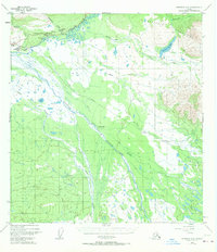
1948 Map of Nabesna C-6
USGS Topo · Published 1970About this map
The confluence of the Copper River and Slana River dominates this interior landscape, which was recorded just before mid-century. The settlement of Slana serves as a local hub along the Glenn Highway, marked by essential infrastructure like the Highway Maintenance Camp and a Radio Tower. Further east, the Nabesna Road branches off, leading toward the foothills of the Mentasta Mountains.
Find a feature on this map
23 named features on this map. Tap any name to fly to it.
Don’t see what you’re looking for? This feature index may not catch every label — zoom into the map to look around manually.
Map Details
Editions of this 1948 Nabesna C-6 Map
4 editions found
Other maps of this area

1948 · Nabesna C-6
USGS Topo · 1:63,360

1948 · Nabesna D-5
USGS Topo · 1:63,360

1949 · Nabesna D-6
USGS Topo · 1:63,360

1949 · Gulkana C-1
USGS Topo · 1:63,360

1950 · Nabesna
USGS Topo · 1:250,000

1950 · Nabesna D-5
USGS Topo · 1:63,360

1951 · Gulkana
USGS Topo · 1:250,000

1951 · Nabesna
USGS Topo · 1:250,000

1952 · Nabesna C-6
USGS Topo · 1:63,360

1952 · Nabesna D-5
USGS Topo · 1:63,360