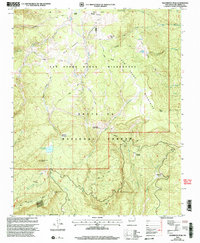
2002 Map of Nacimiento Peak
USGS Topo · Published 2003About this map
Nacimiento Peak rises as a central landmark in this high-altitude landscape within the Santa Fe National Forest, where the complex drainage systems of the San Pedro Mountains converge. The high meadows of the San Pedro Parks Wilderness define the northern half of the area, characterized by open spaces like Vega del Oso and a dense network of pack trails including the Vacas Trail and Penas Negras Trail. To the south, the terrain descends toward Eureka Mesa and the drainage of Clear Creek. Significant water management and recreational features are evident at the San Gregorio Reservoir, while the presence of a Mine and an Electronic Site near the southern boundary indicates the varied land use managed by the Coyote Cuba Ranger District. This 2002 revision preserves the alignment of old forest routes such as the Anastacio Trail through Vallecito Damian.
Find a feature on this map
40 named features on this map. Tap any name to fly to it.
Don’t see what you’re looking for? This feature index may not catch every label — zoom into the map to look around manually.
Map Details
Editions of this 2002 Nacimiento Peak Map
This is the sole edition of this map. No revisions or reprints were ever made.
Other maps of this area

1890 · Jemes
USGS Topo · 1:125,000

1892 · Jemes
USGS Topo · 1:125,000

1909 · Gallina
USGS Topo · 1:125,000

1937 · Jemez Springs
USGS Topo · 1:48,000

1939 · La Ventana
USGS Topo · 1:62,500

1940 · Cuba
USGS Topo · 1:62,500

1943 · Cuba
USGS Topo · 1:62,500

1943 · La Ventana
USGS Topo · 1:62,500

1944 · Jemez Springs
USGS Topo · 1:62,500

1952 · Jemez Springs
USGS Topo · 1:62,500